

On the Road —
‘The French Connection’: Interstate Route 11 – A Biography of a Highway in Pictures
Wayne Brew, Montgomery County Community College
Introduction
In the summer of 2014 I continued a project that will eventually take me along the whole length of Interstate Route 11 from the border with Canada at Rouses Point, New York, to just outside New Orleans. This link will take the reader to a map showing the length of Route 11 (last checked July 2015).
It is rare when a sequel is better than the original, but they are occasions when it is fairly good. The movie French Connection II did not garner any Academy Awards, but was a solid continuation of the story. I hope the reader finds this continuation of my travels interesting.
In July 2014 I picked up my journey in Scranton, Pennsylvania and traced Route 11 to Knoxville, Tennessee. My project goal is to document the landscape as it exists in the early 21st century, but also peel back the layers of history using the existing structures and USGS Historical Topographic Maps. The project is not designed to be a full historical assessment, but rather a selective study of the vernacular and commercial structures with a close eye kept open for the reuse of buildings. Please refer to PAST 2014 for a brief history of Route 11 and a summary of the first leg of the journey.
Interstates created prior to the 1955 Interstate and Defense Highway Act were designed to use existing roads whenever possible and to go through cities (and county seats) on busy thoroughfares (‘Main Street’). Whenever possible I follow the current pathway marked as Route 11, but also consult the historical USGS topographic maps to identify the original route through cities (and for other locations) and follow that route also. I have found that the historical USGS maps are user friendly, informative, and can be accessed at the link provided below. This website has proved to be invaluable to completing this project: http://historicalmaps.arcgis.com/usgs/
The Tennessee Two-Step
Although the map referenced above does not show it, part of Route 11was officially split into two routes from Bristol to Knoxville Tennessee. This is a story of politics, preferences, and compromise with Governor Austin Peay caught in the middle trying to please everyone. In the end Route 11 was split into 11 West (11W) and 11 East (11E). 11W is named the Lee Highway with 11E called the Andrew Johnson Highway. What becomes clear to the present day traveler is that 11W became the preferred route for folks using the highway as a through route and over the years it has been widened for long portions leaving the original road going through the smaller hamlets and the present road as a bypass. According to evidence in the USGS Historical Maps most of widening was completed between 1969 and 1976. See Figure 1 for a picture of the old road surface (and width) of 11W. Another observation is that the split seems to have a dampening effect on the amount of roadside commercial development especially a distinctive lack of motels. A more detailed account of the split in
Tennessee can be found here.
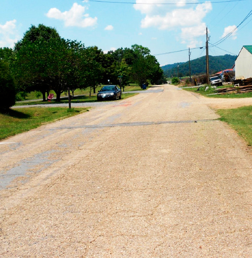
Figure 1: The two-lane old surface of Route 11 West that now acts as a feeder road for the present four-lane highway and also remains the main street for the smaller towns along the route.
Diners
The first of the manufactured (stainless steel) diners that still exist as such was found just over the border in Pennsylvania after crossing the New York border (see PAST 2014). Diners were more prevalent in Pennsylvania, but there were several that I remember in my youth that are now gone. The definitive book “Diners of Pennsylvania” by Brian Butko and Kevin Patrick (Stackpole Books, 1999) has listings for over 10 diners from the New York border just to below West Nanticoke alone, the thickest concentration to be found along any part of Route 11. To the south the concentration is not as great and there are another five diners before the border with Maryland. As expected, the manufactured, steel diners become scarcer with none found in Maryland, West Virginia, and Tennessee. Two were found in Virginia. Figure 2 is a collection of dinerjourneys found along Route 11 for this leg of the .
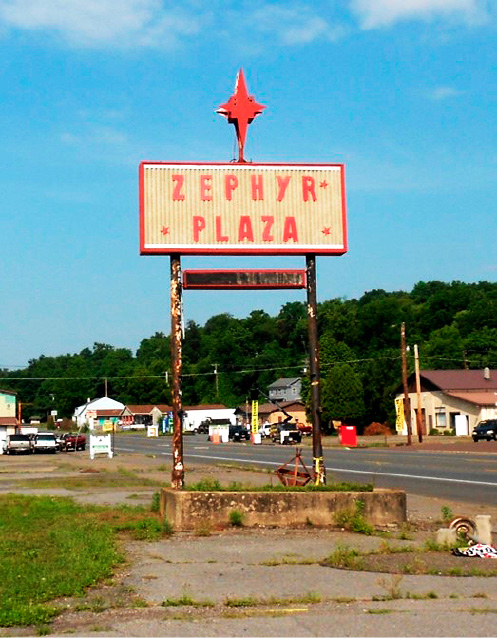
Figure 2a: Only the sign remains of a diner location (Zephyr Diner) north of Bloomsburg, Pennsylvania. The diner was moved to Cleveland Heights, Ohio.
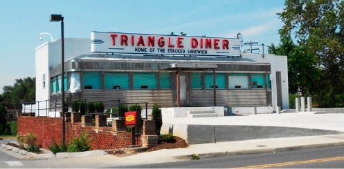
Figure 2b: A nicely restored diner near Winchester, Virginia that was not open to serve me a ‘stacked’ sandwich.
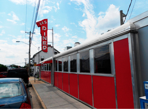
Figure 2c: The L & S Diner in Harrisonburg, Virginia.
Drive-Ins
Having no success finding any visible evidence of Drive-In Theaters during the first leg of my journey I found many more along this leg of my journey starting just south of Scranton. It is an interesting quirk that USGS maps label drive-in theaters on the maps. I speculate that being a relatively new feature on the landscape that labeling them on the map as they appeared made more sense than coming up with a standard symbol for them. An historical USGS map inventory has at least 10 in Pennsylvania, with three still being used as drive-ins. Maryland had none and West Virginia had one on the map, but no visible evidence was found. Virginia had the most with 13 with only two still used as drive-ins. 11W in Tennessee had one and 11E had four; no visible evidence was found for any of the five. Figure 3 is a collection of drive-ins and signs found along Route 11 for this leg of the journey. Figure 4 documents some interesting reuses.
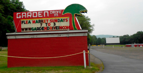
Figure 3a: The Garden Drive-In just south of West Nanticoke, Pennsylvania operates with two screens during the evenings and as a flea market on Sundays.
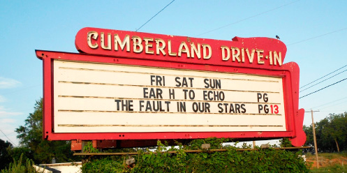
Figure 3b: The Cumberland south of Carlisle, Pennsylvania operates on weekend schedule.
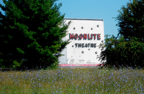
Figure 3c: The Moonlight west of Chilhowie, Virginia sits overgrown.
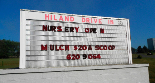
Figure 4a: The Hiland Drive-In near Staley Crossroads, Virginia has been converted to a nursery and the screen structure is reused as a house (4b, at the top of the following page.)
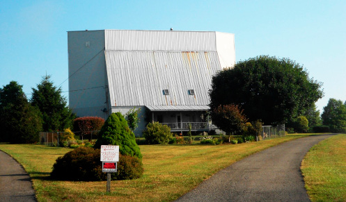
Figure 4b: The Hiland Drive-In near Staley Crossroads, Virginia, has been converted to a nursery and the screen structure is reused as a house.
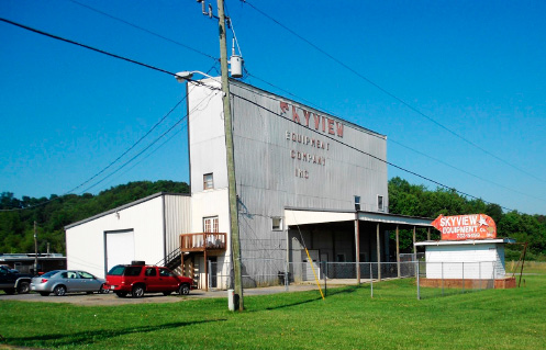
Figure 4c: The Skyview west of Marion, Virginia is being reused as an equipment supply location converting the screen structure for storage and adapted the old sign.
Motels
Similar to the first leg of the journey, many of the early motels have not survived into the 21st Century and many of the ones that have are now used as apartments for local folks. I found a cabin style motel still in use in Virginia and several are now being used as storage facilities. Figure 5 is a collection of motels and signs found along Route 11 for this leg of the journey.
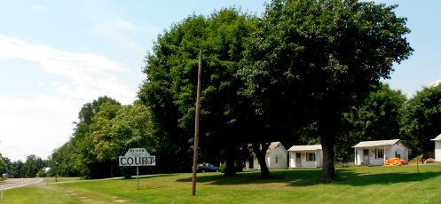
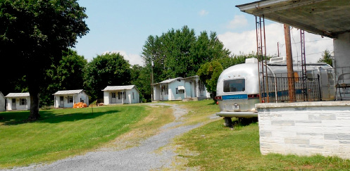
Figure 5a and 5b: The Mountain View Court Motel in Bowman’s Crossing, Virginia is still operating with cabins now catering to a more local clientele as apartments.
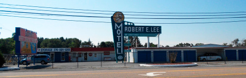
Figure 5c: The restored sign says motel, but the reuse is storage (Abington, Virginia).
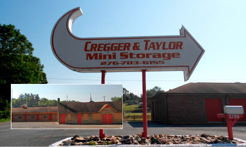
Figure 5d and 5e (inset): A less tidy looking reuse of a motel to storage.
Gas Stations
Many gas stations once lined Route 11, but most of the older ones are no longer in use or have been repurposed for other businesses. One of the striking things on the second leg of the journey was the numerous vernacular gas stations found. This type of gas station design is referred to as “Cube and Canopy” by Keith Sculle. The cube and canopy is ubiquitous, but the increased prevalence along Route 11 starting just across the border of West Virginia is notable. After taking pictures of many I made a decision to stop documenting many of them unless they provided an example of an interesting reuse. Please refer to Keith Sculle’s pioneering work on the cube and canopy gas station and reuse in PAST.
Figure 6 is a series of images documenting the ‘cube and canopy’ gas stations along with some interesting reuses. Figure 7 is a series of images that documents the cottage style gas stations that are also prevalent along this stretch of Route 11.
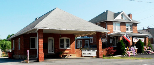
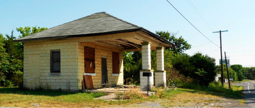
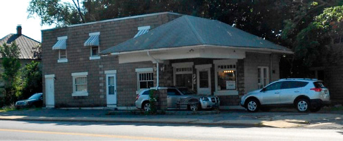
Figure 6: Several variations on the ‘cube and canopy’ gas station including some interesting reuses. 6a (top): Flower Shop and Hair Salon (Hair It Is) in Marlow, West Virginia. 6b (middle): Not much further down the road an abandoned gas station looking for a reuse, but most likely the wrecking ball. 6c: A men’s barber shop.
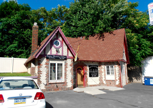
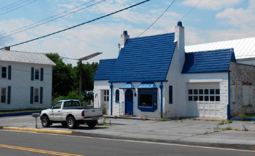
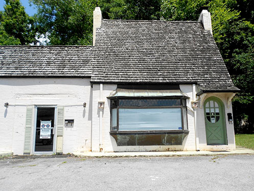
Figure 7: Several variations on the cottage style gas stations. 7a (top): A gentrified dog grooming Tudor cottage in Scranton, Pennsylvania. 7b (middle): A nicely restored blue-roof cottage gas station looking for a reuse in Mount Jackson, Virginia.7c (bottom): A parking area for an ophthalmologist in Rogersville, Tennessee.
Conclusions (Odds and Ends)
As one would expect the memorials switched from Union to Confederate in Virginia along with more battles site locations. Just north of the town of Inwood, West Virginia are several log structures in different stages of up-keep (see Figure 8). Figure 9 is a restored modern/art deco influenced gas station; rarely found in the south in my experiences. Figure 10 is a collection of images of interesting reuse of commercial structures and signs.
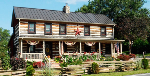
Figure 8a: A well restored house with new worm/snake fence in front that just says “Look at me, I am historic.”
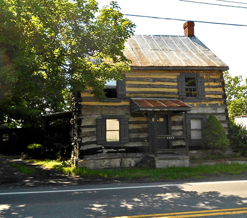
Figure 8b:: Not much further down the road another well-maintained log house.
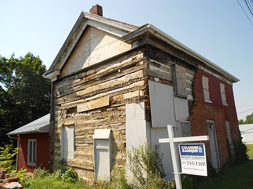
Figure 8c: A not-so-well-maintained ‘fixer-upper’ that was once updated with a brick façade.
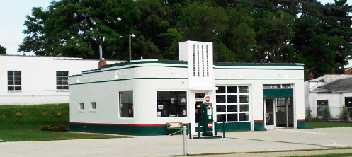
Figure 9: A fully restored modern/art deco influenced gas station in Lexington, Virginia. The restored gas pump in the front has an “Amoco’ label, but this station does not appear to be a standard design by any company.
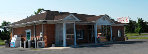
Figure 10a: A coffee shop that was once a bank (note the classical revival details); the drive through window (not seen in photo) comes in handy.
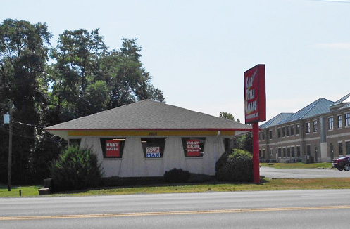
Figure 10b: A company (Car Title Loans) that distributes a dough very different than the Pizza Hut it replaced. I saw a similar business that is reusing a gas station/convenience store (both are located in Virginia).

Figures 10c and 10d: (Left) This old Texaco sign once called to fill empty tanks and now is in the business of filling empty spirit tanks. (Right) This old neon motel sign (now painted) has been reused to advertise the common reuse of motels; apartments.
The summer of 2015 has slipped by me without completing the last leg of the journey from Knoxville to NOLA. I look forward to the continuation of my adventure and will report on the last leg in PAST 2016.
Return to top