

A Cultural Landscape Report:
Beaver, Pennsylvania and its
Central Public Squares
Rebekah Johnston
Introduction
Beaver, Pennsylvania is a town of quaint feeling and historic values. Established in 1793, the town is located at the tributaries of Beaver and the Ohio Rivers in Western Pennsylvania, although it was not incorporated as a borough until 1802. With predominately Victorian homes lining the residential streets within the original town plan, Beaver reminds one of a bygone era. The significance of Beaver’s town plan is its historic urban form centered on existing public squares that have remained largely intact over 200 years of development. The four central public squares, Agnew, Quay, McIntosh and Irvine, historically functioned as a place to weigh hay, feed animals, and gather water for the home. Over time, the public squares transitioned from common ground to leisure park.
The purpose of the research was to explore and document the historic evolution of these public squares as a means of informing contemporary urban planning and design. Specifically, this study investigated the design and evolution of McIntosh Square, including the installation of the Soldiers and Sailors Monument. Additionally, I offer suggested treatment measures for any public use deficiencies that were found. The public squares of Beaver were designated by Governor Mifflin to be used for public space. Irvine Square had as many as three buildings, two churches and a school, in the early years before map making of the town was available. McIntosh and Quay were always left as open space with no structures for hay and water, and Agnew Square always had a courthouse. Though town council officially started making changes to the public squares in the 1870s, before the two churches were removed, these changes began the process of signifying that the public squares were no longer common ground. Residents could no longer retrieve water or hay from these public squares. They were now to be used as a location of relaxation and public events.
Beaver was also selected for this study because its historic urban form has undergone limited change. Beaver has been nominated and registered as a historic place, but based on the nomination form, was considered primarily for its architectural characteristics. The historic nomination form documented prominent architecture styles, for example Italianate and Romanesque (Taylor and Taylor 1994, 89B). However, the landscape of the town was not specifically discussed, and the grid pattern was only briefly noted with regards to the original survey. The use of the public squares and their relationship to the town were also not addressed in previous research. Given the relatively few revisions since their foundation, the public squares became the focus of the study. The primary research question was: what is the historical significance of the public squares and the use of the land through Beaver’s history? Observation and research of the landscape history documentation of McIntosh Square will provide insight into the placement of the Soldiers and Sailors Monument.
Overview of Historic Preservation and a Cultural Landscape Report Approach
Historic landscapes are considered built landscapes that have heritage with significance and should be considered for preservation status or researched to protect the history of the site or structure. Historic landscape preservation is a newer field within landscape architecture. Prior to the 1970s, historic landscape preservation was considered a dominant field for architecture but not landscape (Melnick 1983, xi). Increasing interest in historic landscape preservation generated more research and writings in the field. One method that was developed to guide historic landscape research and writing was the cultural landscape report (CLR) approach.
Cultural landscapes are defined as landscapes affected by people either through design or by impact. The CLR approach guides scholars in the analysis of landscapes that have had a significant impact within the community, environment or an event in history. The framework for documenting a CLR was written in the 1990s, but the writings on historic landscape preservation began in the 1970s.
CLRs are a detailed report containing three main ideas to guide the researcher in the documenting process of a historic landscape. Each section documents the history of the site, analysis of the site, the existing conditions of the site, and treatment recommendations. Beaver as a topic for the research through a CLR was a candidate to understand the changes to the town, the urban form of the town and the changes to the public squares. The CLR approach was methodology that was born out of the historic landscape preservation movement. A cultural landscape report allows the historian to examine and explore the history of the landscape. The report discusses the memory of those who experienced or were part of the landscape, either in design, in an event or through the person who made the landscape significant. The CLR approach also examines and analyzes the historic significance of the landscape. Analysis of the landscape discusses the importance of the existing features and the history of the landscape. The history of the landscape is the key element justifying preservation. The National Trust for Historic Preservation recognizes that landscapes of historic significance should be preserved as part of our cultural history (The National Trust for Historic Preservation in the United States 1976, 186). Documentation of the landscape should also consider the ecological significance of the site as a means of ensuring preservation (Schuyler and O’Donnell 2000, 73). As landscape preservation moves forward and additional landscapes are documented, the body of knowledge grows, and the practice becomes more relevant while furthering the field of landscape architecture.
Research Process
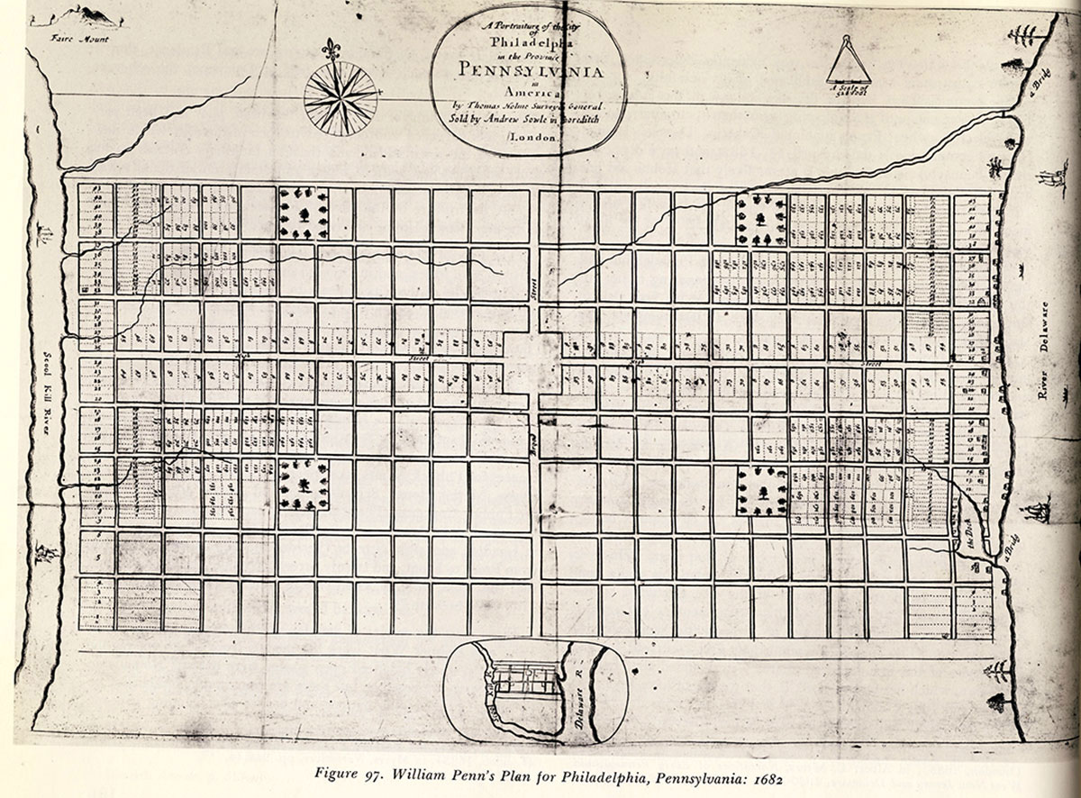
In 1996, Beaver, Pennsylvania was accepted onto the National Register of Historic Places. The nomination form required that the town be considered for Historic Preservation but did not address the relationship between the grid pattern and similarities found in the urban form of Philadelphia. In addition, other 18th-century towns platted by the Commonwealth of Pennsylvania included Warren, Waterford, Erie, Franklin and Allegheny City. Beaver and Allegheny City, now called the North Side in the city of Pittsburgh, were established in order for the land to be sold to replenish the funds of the Revolutionary War. The remaining four towns were established to expand the commonwealth’s land holdings to the west of the Allegheny Mountains. All followed a grid pattern and are all registered as historic districts. As seen in Figure 1, Beaver is distinguished by its four central and four outer public squares, similar to Philadelphia, strategically located in the center and corners of the town.
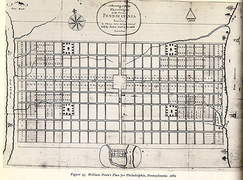
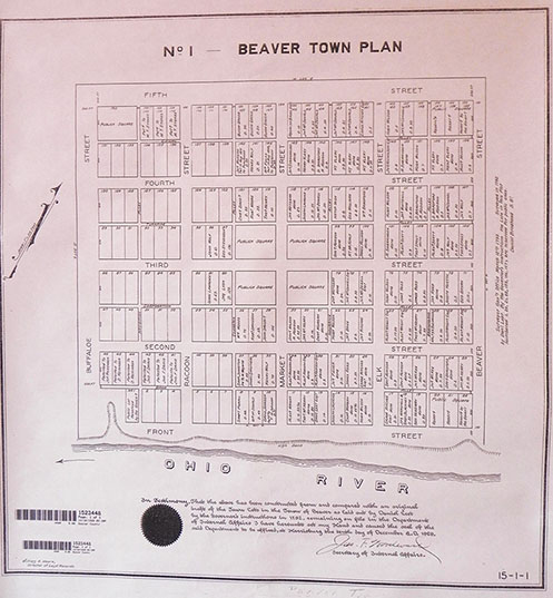
Figure 1. Philadelphia in 1682 (Reps 1965, 162) and Beaver, Pa. in 1793 (Beaver Recorder of Deed’s Office) For a larger view of the top image, click here.
The research for Beaver was done under the exhaustive category, which allowed me to discuss with residents the changes made to McIntosh Square, as well as review the historic documents, maps, Beaver Council Meeting Minutes, postcards, and photographs. Historic maps included Daniel Leet’s layout of the town in 1793, Sanborn Fire Insurance Maps from 1886 through 1925, and a 1941 Works Progress Administration Map, documented the changes made to the form of the town as well as its four central public squares.
Historical Setting
Though Philadelphia was surveyed in 1681, the plan of William Penn and Thomas Holme, Penn’s Surveyor, showed that Penn and Holme wanted the city to have large lots and be in a grid pattern for easy access and public squares (Oberholtzer 1912, 20). Beaver was surveyed in 1793 and Daniel Leet’s plan of the town, showed a certain similarity of grid pattern use, street width and the number of public squares. Leet’s town plan was the only city development to contain more public squares than Philadelphia. The uses of these public squares have changed since 1812, from a common public square to a more recreational use for public gathering such as festivals. The town’s residents changed from agricultural workers to lawyers and businessmen as the little town grew into a more prominent role as a county seat. Since the 1870s when the borough implemented an improvement to the town, adding trees and allowing a more natural feel to the public squares have been a focus for the town and have provided a more prominent opportunity for the residents to be involved in the use and beautification of the public squares.
In the celebration of the county’s 100th anniversary, a more significant change occurred in the public squares with the addition of the Soldiers and Sailors Monument. With this addition, it established that the town council no longer viewed the public squares as a location for gathering water and hay, but as a place to stroll and sit, as public benches were also added at this time. The installation of the Soldiers and Sailors Monument set the stage for the other public squares and all of the public squares were used in a leisure purpose.
The plan of Beaver that was established in 1793 has seen relatively little change. The “out lots” that were established in 1793 were eventually subdivided and became the suburb of Beaver; but that did not happen until World War II in the late 1930s and 1940s. The squares of Beaver with the “in lots” has also seen very little change. Historically, this is significant, since Philadelphia expanded out of Holme’s and Penn’s controlled grid pattern within 20 years. Beaver has grown structurally, as most towns and cities will, but the structures that have been added to the town have remained predominately on the same lots that Leet laid out in 1793.
Analysis and Existing Conditions
The historical value of McIntosh Square is not just the community’s use of the land but also the intactness of Beaver as an historic town. Public squares in the other Commonwealth towns have been subjected to various changes in the use of the land; however, Beaver’s town council and residents have maintained McIntosh Square as a public space with community events, but not with open recreation, such as baseball or football. In the urban form of town planning for Beaver, the public squares’ maintenance and use have been significant to the community. Without the public squares the town’s public use space may have been limited or non-existent.
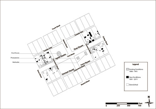
Figure 2. Overlay of 1891 Map (Sanborn Perris Map Company, “Beaver, PA,” map, October 1891). View this image larger.
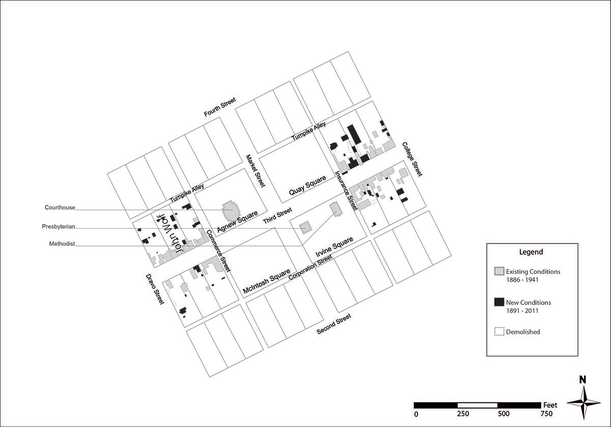
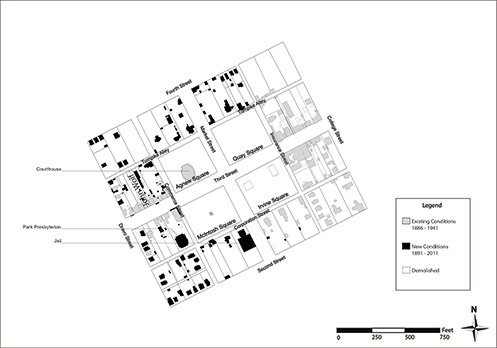
Figure 3. Overlay of 1906 Map (Sanborn Map Company, “Beaver, PA,” map, December 1906). View this image larger.
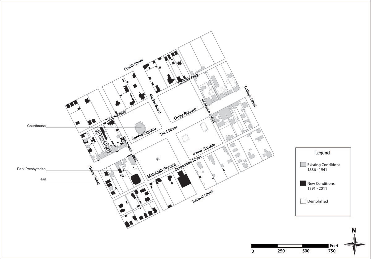
Analyzing the town required overlaying maps to document the changes of the town. As seen in Figures 2 and 3, these two maps from 1891 and 1906, show where the original dividing lines of Daniel Leet and the new buildings of the town surrounding, just the central public squares had changed in a 15 year span. The two years also document the how the public squares went from common public ground to include the courthouse and two churches, to leisure parks with the installation of the monument in 1900 and the demolition of the two churches. These two maps also document that McIntosh Square had relatively few changes that affected the physical features of the public square and provided passive recreation for the community with a walkway surrounding the monument. The contemporary use of Beaver’s public squares started in 1870 when the Town Council began a tree planting program, and since then the town council has gradually transformed the squares into a leisure park.
Some of the changes over time involved safety, seating, and cleanliness. Around 1903, lighting was added to the squares; however, there is no current pedestrian lighting. As a treatment recommendation, I recommended providing appropriate lighting for the public squares to offer a sense of security and safety to the residents (10 Principles for Successful Squares, Project for Public Spaces). Just prior to the dedication of the Soldiers and Sailors Monument, in 1900, twelve benches were purchased and placed in the public squares (Borough Meeting Minutes 1900, 364). The meeting minutes did not document which public squares would receive the benches and how many were to be in each square. Those benches were eventually replaced with the existing benches that are on concrete slabs and have concrete legs with wooden slates. Beaver Borough Meeting Minute’s also discuss the trash receptacles. The minutes discussed adding receptacles in the public squares in the 1930s (Borough Meeting Minutes 1930, 56). As a treatment recommendation, I recommended new trash receptacles that are larger and could blend in with the historic characteristic of the public squares.
The only dedicated monument to grace the interior of a public square in Beaver is the Soldiers and Sailors Monument in McIntosh Square which was installed in 1900. Once the town council agreed to the monument’s placement, the other three public squares began to be used in a more leisure fashion. Prior to the installment of an honor roll and gazebo in Irvine Square, the use of the public square was to house the Chautauqua festival, from 1923 to 1930. After those years, Irvine and Quay Squares were designated as Honor Rolls locations, which were located off the main sidewalk, surrounding the external perimeter of the squares. As seen in Figure 4, the Soldiers and Sailors monument is located in the center of McIntosh Square. Placing three other memorials to honor various other wars in McIntosh Square would have detracted from the significance of the Soldiers and Sailors Monument.
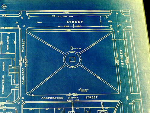
Figure 4. Project Number 25152 1941 (Beaver Area Heritage Museum)
The Soldiers and Sailors monument was designed to be viewed on all four sides, and the circular walk enhances that view. Since the incorporation of the Soldiers and Sailors Monument, McIntosh Square has sustained a number of landscape planting changes. The monument was placed amongst trees planted in the 1870s. There was no designated plan then, and after the storm of 1924, the designated plan was abandoned, so trees were once again planted “randomly.” Even with the landscape plan of 1925 that was never installed, the walk and most of the trees present on the site are from the late 1920s, as can be seen in Figure 5.
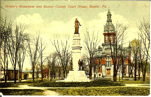
Figure 5. Soldiers and Sailors Monument prior to 1932 (Beaver Area Heritage Museum)
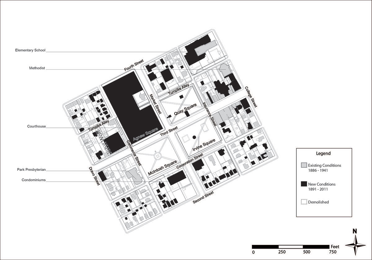
The impact of populations moving away from city centers toward suburban sized lots and lower density environments have raised the awareness of what it takes to create livable cities. Studying towns like Beaver that have sustained themselves over more than a century can provide valuable insight into the development of modern day town plans. Most of Beaver is walkable and one can gain access to any public square or store by bike or walking. Though the average age of the population of Beaver may be older, there is public transportation available. New housing developments may be miles from the city and can only be accessed by car, but the “out lots” of Beaver still provide quick access to the town. Figures 2 and 3 are two of ten overlay maps that were produced for the research of Beaver to understand and document the minimal changes made to Beaver and the Central public squares. This analysis of the maps and the analysis of photographs of the public squares showed how much Beaver retained most of the original format of the town from 1793. Figure 6 is the final overlay map of the analysis to document Beaver in 2011 with a combination of all the previous maps with existing structures and then including Geographical Information Systems (GIS) mapping and Google Earth for structures to determine overall the changes to Beaver between the 1940s and 2011. This final map also shows how little change there has been in the urban form of Beaver, and how the town has been able to retain its small town sensibility.
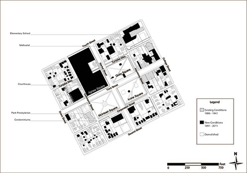
Figure 6. Overlay of 2011 Map (Michael Baker Corporation, “GIS Beaver Parcel Data Map,” map, (accessed June 29, 2011). View this image larger.
Summary
Throughout history, the concept of the “public square” has been to provide a gathering space or a significant spatial relationship with the surrounding architecture (Zucker 1959, 11). The key goal of the public square is to provide residents and visitors a location to come and intermix (10 Principles for Successful Squares, Project for Public Spaces). The public square gives residents a place to sit and communicate with family and friends. The public squares have served as a multi-purpose avenue for the residents of Beaver. Beaver residents can walk to businesses within the town center and can walk to any of the eight public squares as they have down for over 200 years. The preservation of these historic landscape features, surrounding the use of the land of the public squares, allows future planners and preservationists to consider that public squares, no longer a place for the domestic livestock, are a place to gather together as a community.
Beaver contains a similar layout and design to Philadelphia, especially compared to other 18th-century towns platted by the State of Pennsylvania. When Leet laid out Beaver, Philadelphia was already transformed into a city that was beyond its original boundaries. Thus, studying the intact urban fabric of older towns that have not been greatly influenced by 21st-century growth can illustrate historic standards and principles of town planning that are not otherwise visible in larger urban centers.
The changes surrounding Beaver’s four central public squares show the significance of the small degree of change over a long period of time. Through historical analysis and the documentation of existing conditions, we can see that the use of McIntosh Square transformed from being open public land to a public leisure park. The key moment of change was the dedication of the Soldiers and Sailors Monument in 1900. Although subsequent changes were minimal, they eventually resulted in dramatic shift in the use of the square. However, these slow and incremental changes allowed Beaver to maintain its historic urban form.
I would argue that the eight public squares, particularly McIntosh, Agnew, Quay and Irvine, have provided a cultural, physical and historic center for the community. As the history of the public squares have proven that the land transitioned from common ground, used specifically for the residents of the town to gather, water and hay, to leisure park, the ability to use the park in a more social or natural setting. Once the Soldiers and Sailors Monument was installed in 1900, the installation solidified that the use of the public squares had changed and would no longer serve as common ground, but leisure park. The use of the central public squares became a location for large cultural and social events. This research documented the role of the public squares as a vital and important part of the story of Beaver and should be preserved for future generations as a model for contemporary planning and design.
References
Articles at the Project for Public Spaces. 10 Principles for Successful Squares. http://www.pps.org/articles/squaresprinciples/ (accessed January 23, 2012).
Beaver Borough. Town Council. 1900. Meeting Minutes. 364, 349.
Beaver Borough. Town Council. 1930. Meeting Minutes. 56, 57, 75.
Melnick, Robert Z. 1983. Introduction. In The Yearbook of Landscape Architecture: Historic Preservation. ed. Richard Austin, Thomas Kane, Robert Z. Melnick and Suzanne Turner, xi-xiii. New York: Van Nostrand Reinhold Company.
The National Trust for Historic Preservation. 1976. America’s Forgotten Architecture. New York: Pantheon Books.
Oberholtzer, Ellis Paxson. 1912. Philadelphia: A history of the City and People A Record of 225 Years. Vol. 1. Philadelphia: The S.J. Clarke Publishing Company.
Schuyler, David and Patricia O’Donnell. 2000. The History and Preservation of Urban Parks and Cemeteries. In Preserving Cultural Landscapes in America, ed. Arnold R. Alanen and Robert Z. Melnick, 70-93. Baltimore: The Johns Hopkins University Press.
Taylor, David. 1994. National Register of Historic Places Registration Form. Brookville, PA: Taylor and Taylor Associates.
Zucker, Paul. 1959. Town and Square: From the Agora to the Village Green. New York: Columbia University Press
Author Biography
Rebekah Johnston graduated from Chatham University, May 2012 with a Masters Degree in Landscape Architecture. She received her Bachelors of Science in Communications Design from La Roche College in May of 1999. She worked with the Beaver Area Heritage Museum, Beaver County Genealogical and History Center, and obtained information from the Historical Society of Western Pennsylvania as well as the Carnegie Library in Oakland for historic research on Beaver, Pennsylvania and its Central Public Squares. The thesis was completed in defend to fulfill the requirements of the Masters of Landscape Architecture Program in April of 2012.