

Access to Geographical Information in Library Catalogs: a Case Study
Ralph Hartsock and Daniel Gelaw Alemneh,
University of North Texas Libraries
Abstract: Libraries offer a variety of methods to retrieve geographic data. This paper explores three case studies. The original paper, presented during the Pioneer America Society Conference on October 10, 2014, in Oklahoma City, Oklahoma, explored the first three cases. That PowerPoint is available at the the University of North Texas Libraries (UNT) Scholarly repository here.
The online catalog (Case no. 1) includes various materials available to users. These include maps, audio or video recordings, and music. Many of these have place of capture or recording that is important in the understanding of the manifestation. Case no. 2 is Special Collections in general, including the Portal to Texas History. Several unique digital collections provide details such as aerial maps, or books and music produced during monumental events (Civil War). Case no. 3 is a particular collection digitized by UNT: The map collection of the University of Texas at Arlington.
This expanded edition also considers events related to a specific place and time, such as recordings made in Oklahoma City, and how to retrieve these.
Introduction
Advancements in digital technologies shape the creation, access, use, and preservation of information resources in profound ways, including for geographic information. Geographic information science is the research field that underlies the creation and application of geographic information systems.
Map and geography libraries usually collect extensively in the areas of geographic information science and geographic information systems. A review of the current landscape in digital libraries and emerging trends shows that there is no shortage of opinions on the role of geographic information systems that allow the combination of geographic/location data with attribute/theme data through computer-driven processes. According to Mark (2003), geographic information science encompasses theories, methods, technologies and data for understanding geographic patterns and relationships. A geographic information system is «a system of hardware, software, data, people, organizations and institutional arrangements for collecting, storing, analyzing and disseminating information about areas of the earth.”
This article is about Geographical Information, not about Geographic Information Systems. Therefore, the discussions will be restricted to the various methods employed by libraries to facilitate access to geographic data. Various emerging web technologies, such as the Web ontology language (OWL), the resource description framework (RDF), semantic Web rules language (SWRL), and other members of the World Wide Web Consortium (W3C) family of specifications, offer powerful data organization, combination, and query capabilities. This paper uses four case studies to demonstrate a variety of methods to retrieve geographic data.
Classification Systems
A library classification is a system that groups related materials together, typically arranged in a hierarchical tree structure. A different kind of classification system is also widely used which allows the assignment of multiple classifications to an object or information resource, enabling the classifications to be ordered in multiple ways, facilitated in machine readable data. Library classification systems are among the tools that facilitate subject access. In other words, classification systems allow users to find out what works or information resources (such as books, serials, audiovisual materials, maps, computer files, etc.) the library has on a certain subject.
Most classification systems are suitable both for aiding subject access and for shelf location. For example, the Library of Congress Classification G covers geography, anthropology, and recreation. Catalogers use the main portion (G) not only to catalog maps and atlases, but to identify the locations of recorded events, musical or non-musical; these include concerts, recitals, interviews, speeches, and conferences.
Many of LC’s other classifications are structured with geographical elements in mind: C-D is world history, E-F is United States History. Still other classifications, such as ML (Musical Literature) are arranged by place in selected areas or chronological periods.
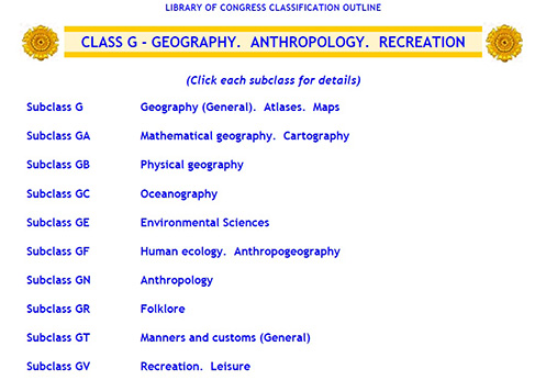
Figure 1. Library of Congress Classification G
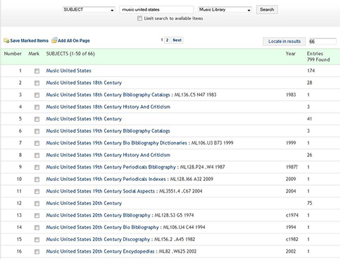
Figure 2. UNT Libraries Catalog for the Subject “Music – United States” with subdivisions following “Music – United States.”
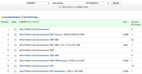
Figure 3. Ohio – Politics and Government, by period
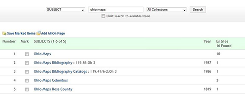
Figure 4. Ohio Maps
Online Catalogs for Subjects, Genres, and Forms
Online catalogs are comprised of a multiplicity of formats and materials: books, manuscripts, music, audio and video recordings, and three dimensional realia. To illustrate this subject approach to the catalog, we use the books and other materials on Music of the United States, as found at the University of North Texas. Nearly 800 items are represented
Many subjects are geographically subdivided indirectly. By this we mean that the geographic zones are in order by country, state, county and city. For some countries, such as the United States, the first geographical element in a subject is the state’s name. Libraries that follow the lead of the Library of Congress assign the most specific jurisdiction or geographical area available. These are known as Library of Congress Subject Headings (LCSH), wihch can be accessed here.
Music – New York – History and criticism
Music – United States – History and criticism
Mounds – Ohio – Ross County
Many local online catalog systems allow these terms to be searched as subjects or as keywords. Many of the examples presented here are from Ohio, which has a longer history and more subdivisions of their politics, government, and history, than does Oklahoma.
The Library of Congress Genre/Form Terms for Library and Archival Materials (LCGFT) terms describe what something is instead of what it is about. Cartographic terms that denote genres and forms include maps and atlases. As of early 2015 it included over 600 terms for moving images (films and television programs), sound recordings, cartography, and law. The Library of Congress and members of the Music Library Association developed an additional 560 genres and forms for music, and over 900 terms in the Library of Congress Medium of Performance Thesaurus for Music (LCMPT). Geographical entities also appear first in subjects that access maps and atlases. (Library of Congress, 2015c)
WorldCat, operated by OCLC (formerly known as the Ohio College Library Center), provides access to over 300 million bibliographic records in all formats: books, recordings, maps, music, and three dimensional artifacts. Over 72,000 libraries in over 170 countries participate. WorldCat Discovery will, in 2016, replace FirstSearch. Noted cartographer T.M. Fowler (Thaddeus Mortimer; 1842-1922) has created hundreds of maps, some in the region of the 2014 conference of the Pioneer America Society.
The physical version of a map, Wichita Falls, Texas, 1890 (Fowler, 1890b), is available at the University of Texas at Arlington. But libraries are reluctant to lend audiovisual materials, including maps, via Interlibrary Loan. The result of this search is shown below.
Fortunately, as is shown later in this article, another option is available.
Special Collections of Maps
In 2002 University of North Texas Libraries began planning The Portal to Texas History, a digital gateway to historical materials from private collectors and collaborative partners, including libraries, museums, archives, and other historical groups. The goal is to structure the Portal in a way that would ensure long-term sustainability. By 2010, the Portal hosted over 900,000 digital images from 130 partners. By 2015, the Portal had grown to host 5.5 million images from over 250 partners. The Portal contains over 82,000 maps, several relevant to Texas and the southwestern United States. (Portal to Texas History). Many of these maps are from the last twentieth and early twenty-first century, but a sizeable number date back to the fifteenth century. In addition to maps, The Portal consists of the digital representations of letters, journals, original documents, photographs, newspapers, postcards, city directories, and artifacts.
The Library of Congress (Library of Congress, 2015a) holds the world’s largest and most comprehensive cartographic collection:
5.5 million maps 80,000 atlases
6,000 reference works 500 globes and globe gores
3,000 raised relief models 19,000 cds/dvds
The online map collections represents only a small fraction that have been converted to digital form, over 13,000. Within these digitized collections is another maps by Thaddeus Mortimer Fowler, of Guthrie, Oklahoma. (Fowler, 1890a) Another substantial collection in the Library of Congress, in its Prints and Photographs Division, displays much history and material culture, with over one million digitized images. (Library of Congress, 2015b). The range of these photographs is reflected by their breadth: American cartoons, Baseball cards, Civil War battlefields, Farm Security Administration, and posters form the Spanish Civil War, the Works Progress Administration (WPA), and World War One.
University of Texas at Arlington Map Collection
The next case study examines a specific map collection, that of the University of Texas at Arlington. Digitized by the University of North Texas, and indexed in the Portal to Texas History, 5,188 maps date from 1493 to the present and feature noted cartographers. While international in scope, the collection emphasizes the region of the Gulf Coast and the Greater Southwest: Texas and other southwestern states annexed by the United States after the U.S. War with Mexico of 1846-1848.
These include historical maps of the region, such as Oklahoma, geologic maps of the Arbuckle Mountains, in Oklahoma, and other local maps, such as land use in Arlington, Texas, in 1980. The previously mentioned map of Wichita Falls, Texas by T. M. Fowler is also digitized in this collection (Fowler, T. M., 1890c).
Geographical information also will aid in the identification of music, interviews, concerts, recitals, and lectures recorded in specific locations. This data is rendered into several bibliographic records about the history of a state, such as Oklahoma.
Advantages to digitization include: 1) the original map us preserved for infrequent in-person usage; 2) access is from anywhere, a desktop computer, laptop, or mobile device; 3) magnification is allowed for detailed study; 4) usage statistics are more easily gathered from digital projects, including country of user, and device used. Certain characteristics, such as watermarks, may need onsite viewing, but digital technology is changing even this.
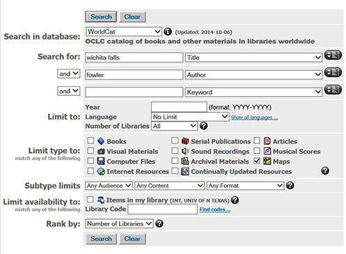
Figure 5. FirstSearch, Search strategy
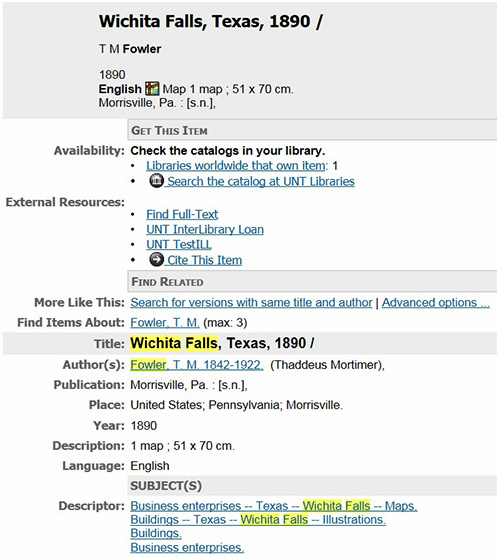
Figure 6. FirstSearch, Search results .
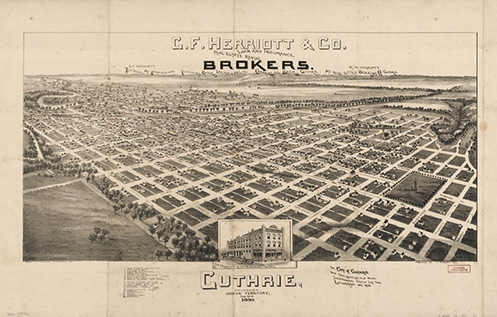
Figure 7. Folwer: Guthrie, Oklahoma, Indian Territory, Jan. 22nd 1890
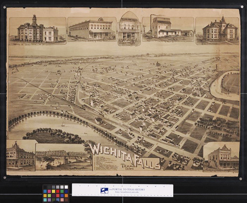
Figure 8. Fowler: Map of Wichita Falls, Texas, 1890
History and Material Culture Derived from Bibliographic Records
Bibliographic records in libraries also provide a historical of record of performances and other events that shaped the material culture of America. The Ronald J. Norick Downtown Library, site of the 2014 conference of the Pioneer America Society, houses Oklahoma Voices, an oral history collection. Each person was interviewed in the library. Subjects range from television personality Barbara Jean Williams to geologist Barth Bracken. (Bracken, 2007)
Music from classical to rock and Contemporary Christian may be found in the history of Oklahoma City. Instrumental in the classical and symphonic music was Guy F. Harrison, conductor of the Oklahoma City Symphony Orchestra. The Library of Congress now holds recordings of the orchestra, broadcast live on KTOK radio (Oklahoma City), and subsequently on the Voice of America. (Oklahoma City Symphony Orchestra, 2004) The rock group, Grateful Dead, performed at the Oklahoma Fairgrounds Arena, in Oklahoma City, on October 19, 1973. (Grateful Dead, 2014) These live recordings are preserved in libraries from Oregon to Ohio. The local recording of Contemporary Christian music, recorded at Victory Church, Oklahoma City is preserved in Resonation. (Victory Church, 2007).
Future Trends
These are but a few of the myriads of recordings, audio or video of various cultural activities with geographical implications. For fifty years the library of Congress has utilized an eight bit memory system to encode bibliographic data, Machine Readable Cataloging (MARC). But on the digital horizon, an evolution to web-compatible resource description framework (RDF) will be manifested in the future by the Bibliographic Framework (BibFrame). This will allow natural language to be use for metadata.
References
Bracken, B., Bracken, P., Metropolitan Library System (Oklahoma County, Okla.), Friends of the Metropolitan Library System., Arts Council of Oklahoma City., & Oklahoma Centennial Commission. (2007). Oklahoma voices : Barth Bracken [CD]. Oklahoma City, Okla: Metropolitan Library System.
Fowler, T. M. (1890a). Guthrie, Oklahoma, Indian Territory, Jan. 22nd 1890. Retrieved March 18, 2015, from http://www.loc.gov/item/2012592346/
Fowler, T. M. (1890b). Wichita Falls, Texas, 1890. Morrisville, Pa.
Fowler, T. M. (1890c). Wichita Falls, Texas, 1890. Morrisville, Pa. Retrieved March 18, 2015, from http://texashistory.unt.edu/ark:/67531/metapth190412/
Grateful Dead (2014). Fairgrounds Arena, Oklahoma City, OK, 10-19/73. [CD] Real Gone Music.
Library of Congress (2015a). Collections with Maps. Retrieved March 18, 2015, from http://www.loc.gov/maps/collections
Library of Congress (2015b). Prints & Photographs Online Catalog. Retrieved March 18, 2015, from http://www.loc.gov/pictures/about/
Library of Congress. (2015c). Thesauri & Controlled Vocabularies. Retrieved March 13, 2015, from http://www.loc.gov/library/libarch-thesauri.html
Mark, D. M. (2003). Geographic Information Science: Defining the Field. Retrieved March 20, 2015, from http://www.geography.hunter.cuny.edu/~yllik/gis2/ lectures/lecture1/mark_2003.pdf
Oklahoma City Symphony Orchestra, Harrison, G. F., Rossini, G., Copland, A., Wieniawski, H., & Voice of America Music Library Collection (Library of Congress) (2004). Oklahoma City Symphony Orchestra, 1960-1961 season: Broadcast no. 19, [1961-03-12]. [audio tape] Washington, D.C.: Voice of America.
University of North Texas Libraries (2015). The Portal to Texas History, Retrieved March 13, 2015, from http://texashistory.unt.edu
Victory Church (Oklahoma City, Okla.). (2007). Resonation [CD]. Oklahoma City, OK: Victory Productions.
Williams, B. J., Riha, K., Metropolitan Library System (Oklahoma County, Okla.), Friends of the Metropolitan Library System., Arts Council of Oklahoma City., & Oklahoma Centennial Commission. (2010). Oklahoma voices : Barbara Jean Williams [CD]. Oklahoma City, Okla: Metropolitan Library System.
Contributor Biographies
Dr. Daniel Gelaw Alemneh, a digital curator in the Digital Library Division of the University of North Texas (UNT) Libraries, has been heavily involved in the creation of the repository services at the UNT Libraries. He has been instrumental in the establishment of the UNTL Metadata standards and PREMIS preservation metadata implementation, where he currently coordinates the UNT’s ETDs related activities. Alemneh received his BS in LIS from Addis Ababa University, Ethiopia (1994), his MA in Library and Information Management from the University of Sheffield, UK (1997), and his Post Masters in Digital Image Management and PhD in Information Science from the UNT (2000 and 2008). Alemneh is also an adjunct faculty member at the UNT College of Information teaching indexing, abstracting, and information retrieval courses. He has a history in publishing and presenting on topics of digital libraries, preservation metadata, ETD lifecycle management and analysis workflows.
Ralph Hartsock, Senior Music Catalog Librarian for the University of North Texas Libraries, catalogs sheet music and dissertations. In the realm of cataloging he published Notes for Music Catalogers: Examples Illustrating AACR2 in the Online Bibliographic Record (Lake Crystal, Minnesota: Soldier Creek Press, 1994). He has published extensively on America’s avant garde composers, including the reference sources Otto Luening: a Bio-Bibliography (Westport, Connecticut: Greenwood Press, 1991), and Vladimir Ussachevsky: a Bio-Bibliography (Westport, Connecticut: Greenwood Press, 2000), the latter in collaboration with Carl Rahkonen. Hartsock has also published articles on Milton Babbitt and Edgard Varese. In addition to over 200 published book reviews, he has also contributed to reference sources on American history (Civil War, Disability history, Countercultures, Movies in American Culture). Topics range from Fanny Crosby, Josephine Griffing, and Ray Charles to Woodstock, and Peter, Paul and Mary.
Return to top